SunCalc Disproves Manila Bay Sunset Will Be Blocked By Manila Solar City
Thanks to FB Friend Atanacio Salvador, outrage faddists will be outed again for a fair bit of deception.
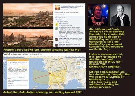
Atanacio sent me an infograph and a link to a site which scientifically disproves the claims of a supposed altruistic movement that the majestic view of the sunset of Manila bay will be blocked by a joint reclamation project by the Manila City Government and Manila Goldcoast Development Corporation.
The infograph shows an artistic rendition of the Manila Bay sunset supposedly as it is now and below this is another rendition of the Manila Bay sunset blocked by tall buildings, supposedly those that are going to be constructed on the Manila reclamation project.
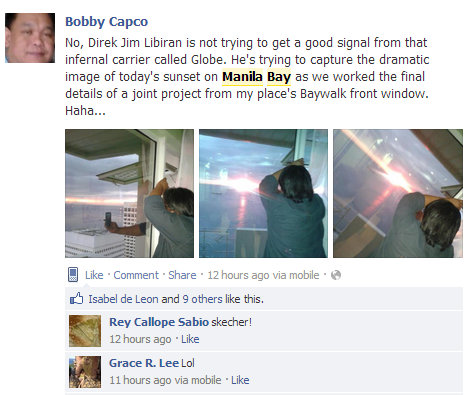
This picture is being circulated by Paulo Alcazaren, Jim Libiran, and other members of the SOS Save Manila Bay movement.
It is a picture that will rile anybody up, unless they’re actually Manilenyos and actually took time to think about where exactly the sun sets.
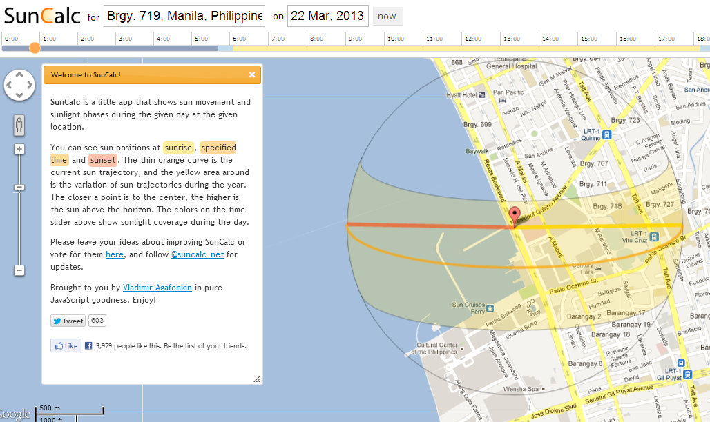
The artist made one glaring inaccuracy, he or she depicted the sun setting towards Quirino Grandstand or towards the Manila Pier.  Here is a closer picture of the erroneous sunset being spread by SOS Save Manila Bay.
Below the picture of the erroneous depiction of the Manila Bay sunset is another picture from SunCalc, a website that “shows sun movement and sunlight phases during the given day at the given location.”  This picture shows where the sunsets around this time of year and clearly, it indicates that the sun sets right towards the center of the bay, NOT towards the Pier.
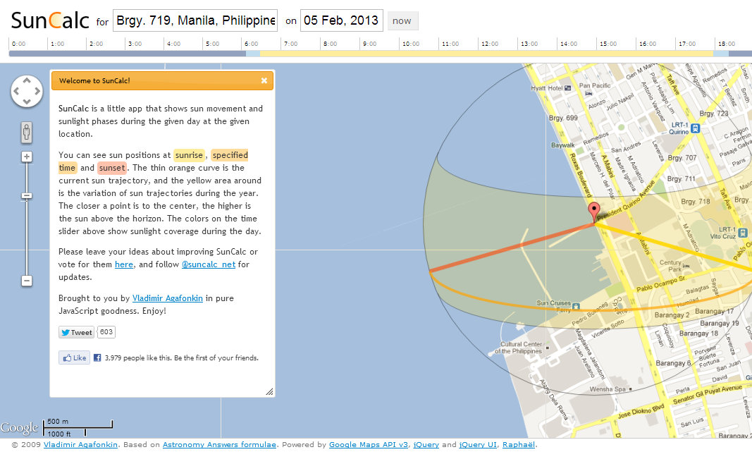
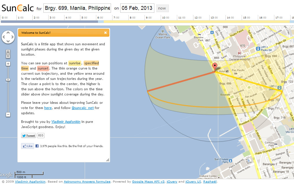
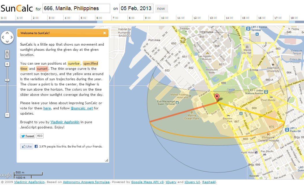
Moreover, I used SunCalc to see whether the proposed Manila Solar City project will block the sunset along Roxas Boulevard and guess what? It won’t.
Check out the sun’s path on Quirino Avenue.
Check out the sun’s path on Malate.
Check out the sun’s path at the Quirino Grandstand.
Of course, the place where the sun sets will differ through out the year and this is because the Earth is slightly tilted. Â Come March 22, the sun’s path will be a direct line crossing east to west and from that point, the sun will set progressively towards Quirino Grandstand.
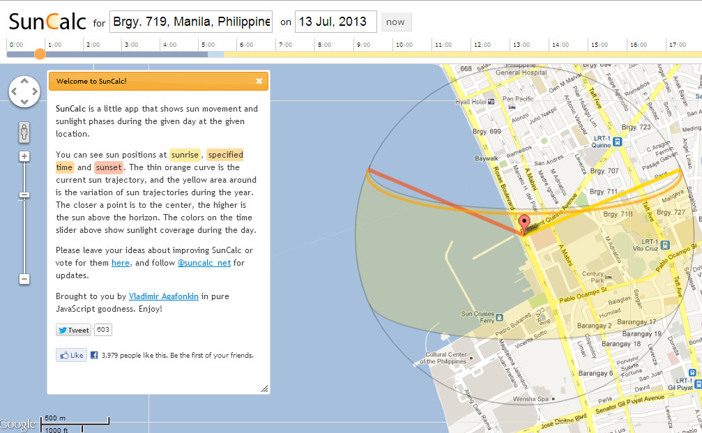
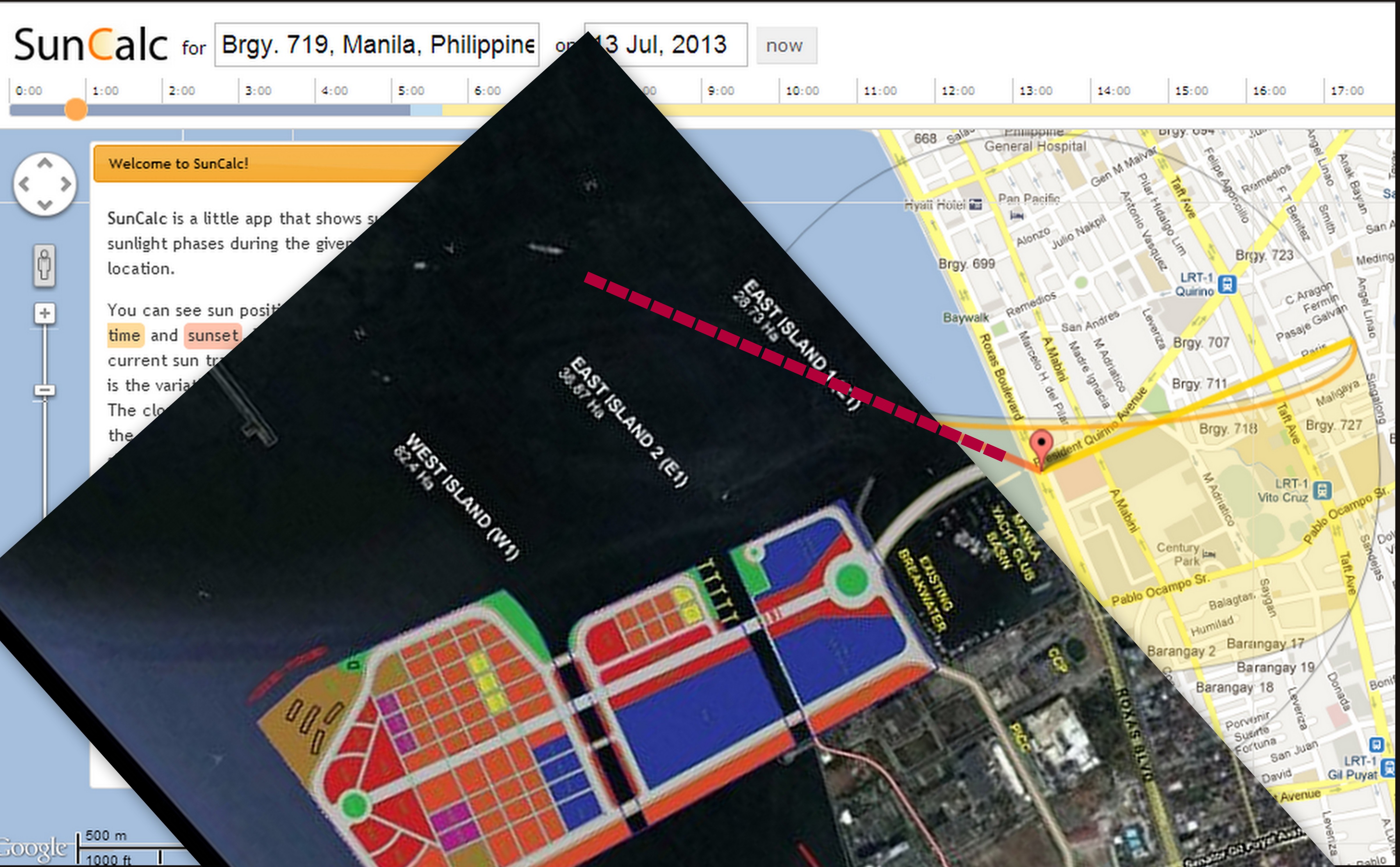
By July 13, the sun will set nearest to Quirino Grandstand.
I think SOS Save Manila purposely timed their sunset viewing at this time of year when the sun sets nearest the proposed site of Manila Solar City. SOS Save Manila is PURPOSELY DECEIVING THE PUBLIC by not telling them that from March onwards, the sun’s trajectory will progressively veer away from Manila Solar City and the succeeding sunsets will be closer to the Quirino Grandstand. Â COMPLETELY MISSING THE MANILA SOLAR CITY DEVELOPMENT!
Even now, the sun’s trajectory barely glances the edge of the proposed development and really, this can be addressed by not building structures that would obstruct the view of the setting sun from Quirino Avenue.
Oh, and Mr. Jim Libiran, I didn’t use fancy equipment for this and am just using FREE stuff on the net. Â Nothing fancy that will obviously need a lot of funding to execute and publish or broadcast.
So, before you insinuate anything, let me ask you… How was your lunch with PR Man Bobby Capco?
Let me end this post with a few words from Atanacio:
Is there such a thing as FREE LUNCH?
How far will these guys go to pursue their so-called public interest agenda? The fact is they are pursuing their own agenda. Public access to the sunset is not limited to that few meters of Manila Bay’s shore. It is available to all in a far wider coastline of the country’s western side. In fact, it shouldn’t be touted by the Department of Tourism as the Manila Bay Sunset… it should be the Philippine Sunset.
The reclamation islands on Manila Bay — yes, ISLANDS — will breath new life (and land) into the old decrepit city that is Manila: new jobs, new business opportunities, new clean and well managed environment.
Yet these sunset savers want to save THEIR “view” — what have they done for Manila lately? And if they are able to stop this reclamation project for the reasons they state, what good will they do then for Manila and its ills?
Kainin nyo sunset nyo! Go ahead, tell that the the poor, starving masses.
Some supporters of the Sunset-watching have made the sunset into a symbol of the environmental condition of the Bay. But there actually may be no connection between environmental condition and the sunset’s quality. What if the actual effect is that the sunset becomes more beautiful the greater the pollution? Then the sunset would be the basis for letting pollution grow more. The more important thing would be rehabilitating the bay for a better use. Perhaps the reclamation is a better way of doing this after all.
1. The claim that the sunset will not be fully blocked by the reclamation development seems to corroborate with the evidence.
2. I claim that the reclamation project should not be done soon (or at all) due to the negative environmental impacts of such addition to the coastal geomorphology.
3. There are red herrings towards the end of the article.
Nevertheless, cheers to the author for an informed narrative.
Check http://www.suncalc.net it shows the sun’s position on Quirino Avenue Corner Roxas Boulevard.
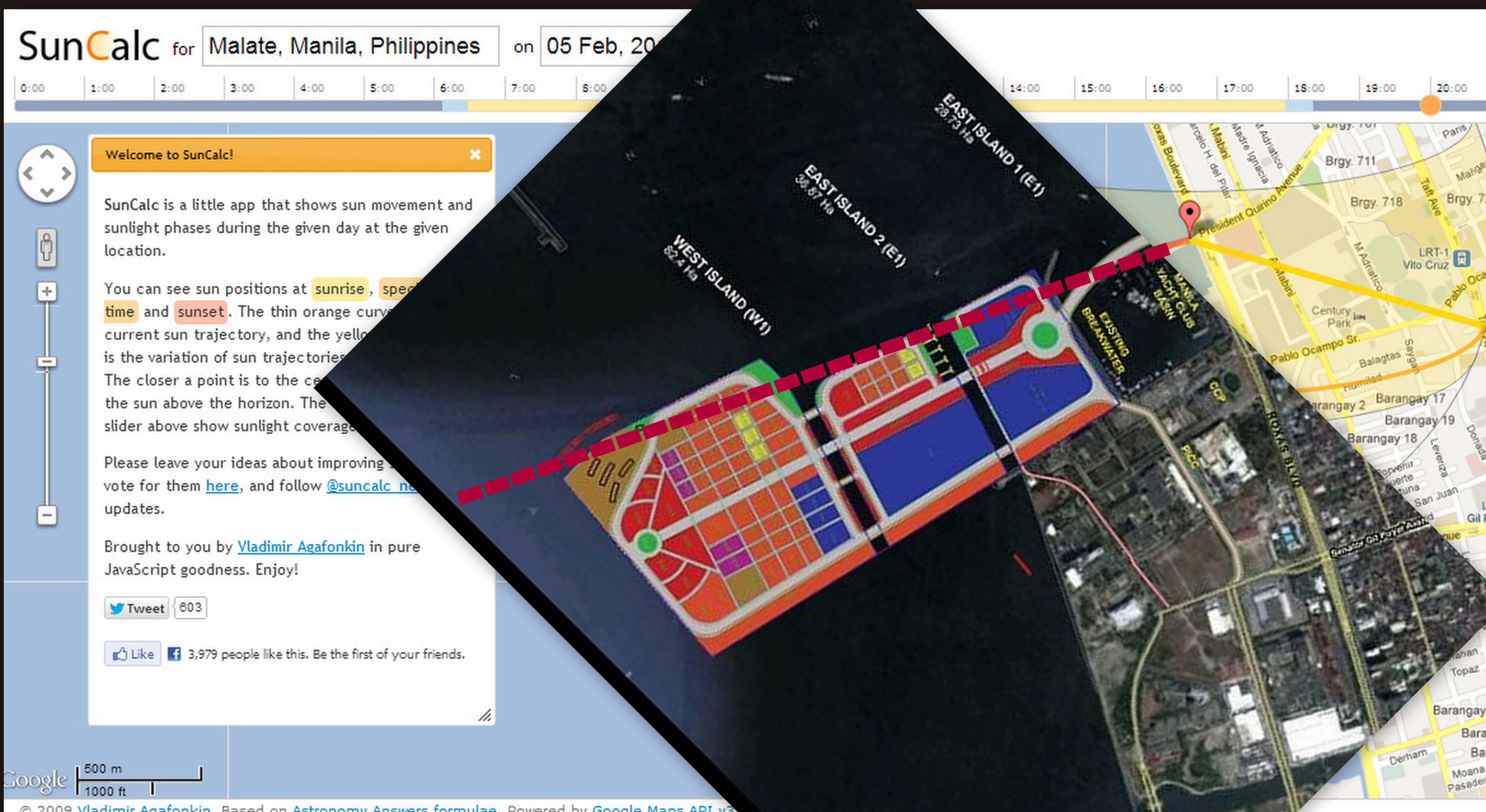
Just by following the links below, you will see for yourself that the sun sets nearest to the proposed reclamation project from December to February. For 9 months, the sun sets at points far away from the reclamation site.
After March 13, the sun begins to set further and further away from the proposed development — more towards Quirino Grandstand as the year progresses.
By July or August, the sun set is at its furthest from the development and then begins to start setting at points going nearer again to the proposed development site.
This is the sunset position Todayhttp://suncalc.net/#/14.5645,120.9851,13/2013.02.06/20:04
This is the sunset position on March 1http://suncalc.net/#/14.5645,120.9851,13/2013.03.01/20:04
This is the sunset position on April 1http://suncalc.net/#/14.5645,120.9851,13/2013.04.01/20:04
This is the sunset position on May 1http://suncalc.net/#/14.5645,120.9851,13/2013.05.01/20:04
This is June 1http://suncalc.net/#/14.5645,120.9851,13/2013.06.01/20:04
This is July 1http://suncalc.net/#/14.5645,120.9851,13/2013.07.01/20:04
This is August 1http://suncalc.net/#/14.5645,120.9851,13/2013.08.01/20:04
This is September 1http://suncalc.net/#/14.5645,120.9851,13/2013.09.01/20:04
This is October 1http://suncalc.net/#/14.5645,120.9851,13/2013.10.01/20:04
This is November 1http://suncalc.net/#/14.5645,120.9851,13/2013.11.01/20:04
This is December 1http://suncalc.net/#/14.5645,120.9851,13/2013.12.01/20:04
This is January 1, 2014http://suncalc.net/#/14.5645,120.9851,13/2014.01.01/20:04
And if the reclamation does block the sunset, all you need do is just go to the back of the reclaimed site and watch the sunset from there. All that for a sunset that doesn’t even really represent the true environmental problems at the place.
I don’t get the whole save the Sunset issue. If they do reclaim the area and build offices, residential spaces etc, wouldn’t that benefit the people of Manila more? Wouldn’t that mean potentially cleaner surroundings since the area would now be maintained properly?
I’d be more concerned if they presented data which would show something like increased flooding if this was to push through, but sunsets? Really?!
Just as I thought. I guess I’ll have to wait and see what they complain about next. I’ve just read a facebook post regarding the supposed 1000 bodies for the sunset and can’t help but just shake my head in dismay. Do these people have nothing else to do?
i think they used the sunset as a symbol para mas dramatic. but let’s put that aside from now.
the problem with this reclamation project is it’s impact on Manila’s flooding every time there’s a typhoon.
another thing is why cant they just build it somewhere else? manila is filled with areas suffering urban decay. granted that developing old areas is harder compared to reclaiming a new one but then again wouldnt it be better for the city to do the former than the latter in the long run?
last, the view from roxas boulevard has its historical and aesthetic value (at least, for me who has lived near it since birth). i guess this last argument is the “weakest” one. we (filipinos) are not known for valuing things that are beautiful, historical or relating to a city’s (or nation’s) identity.
I was going to blog about something else entirely, but it seems there’s more that needs straightening out here.
Let’s just take up one thing in your comment:
“the problem with this reclamation project is it’s impact on Manila’s flooding every time there’s a typhoon.”
If at all “reclamation” has an impact, it is that expands available land.
The reclamation itself will not have an impact in terms of ground subsidence because this phenomena is caused by (1) the weight of buildings on ground prone to subsidence and (2) the extraction of ground water. The thing is, (1) the reclamation site will be built on what was once submerged water, so you are in fact raising the ground and (2) the project will not extract water from the ground.
Moreover, flooding in Metro Manila has been traced to a number of things.
(1) The depletion of the Marikina Watershed
(2) The covering up of natural water sinks and marshes by buildings in Metro Manila
(3) Siltation and blockage of waterways (rivers, esteros, and small flood ways)
(4) Ground subsidence, in some parts of Manila.
Nope, reclamation is NOT a contributor to flooding.
For the proposed reclamation project to be a contributor to flooding from the sea, it would probably have to block the mouth of Manila Bay — that is a 19 kilometer stretch!
The development itself is less than a fraction of that size and NOT even at the mouth of the bay.
If they can’t stop the developers from making the reclamation, then maybe S.O.S. Save Manila Bay can think of other ideas that can save the view at Roxas Boulevard, say make the boulevard more interesting or offer something more than the sunset while complementing it.
Why reclaim this part of manila bay? wala nang space dito. the sunset issue may have some merit but the real issue here is space and the effect of the reclamation to establishments around this reclamation project. why not go to the tondo side of manila bay if you want to beautify manila and help the people with jobs? it would take years to reclaim any portion of the bay area, imagine hundreds of big trucks going back and forth everyday carrying soil and big monoliths in the ccp complex area for how many years? 2yrs? 5yrs? 10yrs?. how about the compaction and settling process of the reclaimed area? how many more years? and then the actual development of the area? how many more years? imagine the effect on the traffic, sira ang tourism and business sa area na eto for many many years just for one company.


Guns are everywhere. More unlicensed than licensed…Rebel carrying guns…the goverment cannot prevent…
They have not yet solved the yearly floods…
Some supporters of the Sunset-watching have made the sunset into a symbol of the environmental condition of the Bay. But there actually may be no connection between environmental condition and the sunset’s quality. What if the actual effect is that the sunset becomes more beautiful the greater the pollution? Then the sunset would be the basis for letting pollution grow more. The more important thing would be rehabilitating the bay for a better use. Perhaps the reclamation is a better way of doing this after all.
1. The claim that the sunset will not be fully blocked by the reclamation development seems to corroborate with the evidence.
2. I claim that the reclamation project should not be done soon (or at all) due to the negative environmental impacts of such addition to the coastal geomorphology.
3. There are red herrings towards the end of the article.
Nevertheless, cheers to the author for an informed narrative.
Check http://www.suncalc.net it shows the sun’s position on Quirino Avenue Corner Roxas Boulevard.
Just by following the links below, you will see for yourself that the sun sets nearest to the proposed reclamation project from December to February. For 9 months, the sun sets at points far away from the reclamation site.
After March 13, the sun begins to set further and further away from the proposed development — more towards Quirino Grandstand as the year progresses.
By July or August, the sun set is at its furthest from the development and then begins to start setting at points going nearer again to the proposed development site.
This is the sunset position Todayhttp://suncalc.net/#/14.5645,120.9851,13/2013.02.06/20:04
This is the sunset position on March 1http://suncalc.net/#/14.5645,120.9851,13/2013.03.01/20:04
This is the sunset position on April 1http://suncalc.net/#/14.5645,120.9851,13/2013.04.01/20:04
This is the sunset position on May 1http://suncalc.net/#/14.5645,120.9851,13/2013.05.01/20:04
This is June 1http://suncalc.net/#/14.5645,120.9851,13/2013.06.01/20:04
This is July 1http://suncalc.net/#/14.5645,120.9851,13/2013.07.01/20:04
This is August 1http://suncalc.net/#/14.5645,120.9851,13/2013.08.01/20:04
This is September 1http://suncalc.net/#/14.5645,120.9851,13/2013.09.01/20:04
This is October 1http://suncalc.net/#/14.5645,120.9851,13/2013.10.01/20:04
This is November 1http://suncalc.net/#/14.5645,120.9851,13/2013.11.01/20:04
This is December 1http://suncalc.net/#/14.5645,120.9851,13/2013.12.01/20:04
This is January 1, 2014http://suncalc.net/#/14.5645,120.9851,13/2014.01.01/20:04
And if the reclamation does block the sunset, all you need do is just go to the back of the reclaimed site and watch the sunset from there. All that for a sunset that doesn’t even really represent the true environmental problems at the place.
I don’t get the whole save the Sunset issue. If they do reclaim the area and build offices, residential spaces etc, wouldn’t that benefit the people of Manila more? Wouldn’t that mean potentially cleaner surroundings since the area would now be maintained properly?
I’d be more concerned if they presented data which would show something like increased flooding if this was to push through, but sunsets? Really?!
There is no indication of any connection between subsidence and the proposed reclamation.
Just as I thought. I guess I’ll have to wait and see what they complain about next. I’ve just read a facebook post regarding the supposed 1000 bodies for the sunset and can’t help but just shake my head in dismay. Do these people have nothing else to do?
i think they used the sunset as a symbol para mas dramatic. but let’s put that aside from now.
the problem with this reclamation project is it’s impact on Manila’s flooding every time there’s a typhoon.
another thing is why cant they just build it somewhere else? manila is filled with areas suffering urban decay. granted that developing old areas is harder compared to reclaiming a new one but then again wouldnt it be better for the city to do the former than the latter in the long run?
last, the view from roxas boulevard has its historical and aesthetic value (at least, for me who has lived near it since birth). i guess this last argument is the “weakest” one. we (filipinos) are not known for valuing things that are beautiful, historical or relating to a city’s (or nation’s) identity.
I was going to blog about something else entirely, but it seems there’s more that needs straightening out here.
Let’s just take up one thing in your comment:
“the problem with this reclamation project is it’s impact on Manila’s flooding every time there’s a typhoon.”
If at all “reclamation” has an impact, it is that expands available land.
The reclamation itself will not have an impact in terms of ground subsidence because this phenomena is caused by (1) the weight of buildings on ground prone to subsidence and (2) the extraction of ground water. The thing is, (1) the reclamation site will be built on what was once submerged water, so you are in fact raising the ground and (2) the project will not extract water from the ground.
Moreover, flooding in Metro Manila has been traced to a number of things.
(1) The depletion of the Marikina Watershed
(2) The covering up of natural water sinks and marshes by buildings in Metro Manila
(3) Siltation and blockage of waterways (rivers, esteros, and small flood ways)
(4) Ground subsidence, in some parts of Manila.
Nope, reclamation is NOT a contributor to flooding.
For the proposed reclamation project to be a contributor to flooding from the sea, it would probably have to block the mouth of Manila Bay — that is a 19 kilometer stretch!
The development itself is less than a fraction of that size and NOT even at the mouth of the bay.
If they can’t stop the developers from making the reclamation, then maybe S.O.S. Save Manila Bay can think of other ideas that can save the view at Roxas Boulevard, say make the boulevard more interesting or offer something more than the sunset while complementing it.
Why reclaim this part of manila bay? wala nang space dito. the sunset issue may have some merit but the real issue here is space and the effect of the reclamation to establishments around this reclamation project. why not go to the tondo side of manila bay if you want to beautify manila and help the people with jobs? it would take years to reclaim any portion of the bay area, imagine hundreds of big trucks going back and forth everyday carrying soil and big monoliths in the ccp complex area for how many years? 2yrs? 5yrs? 10yrs?. how about the compaction and settling process of the reclaimed area? how many more years? and then the actual development of the area? how many more years? imagine the effect on the traffic, sira ang tourism and business sa area na eto for many many years just for one company.